Category Archives: Travel

“The Treacle Mine” Earthcache

Article by Emma Evans, Senior Geophysicist, ION

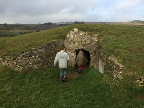
Approximately 3 miles east of Bath near the village of Bathford in Somerset is the Nature reserve of Browns Folly. Underneath the nature reserve is Browns Folly Mine, a large complex of tunnels and caverns created by the demand for Bath stone to build the Georgian city. Part of the complex was subsequently used by the MOD as an ammunition depot during World War II. In recent years the tunnels have become popular with cavers and occasional partygoers and are also home to a number of geocaches including an Earthcache – GC4P440 – Below Above – The Treacle Mine.

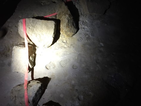
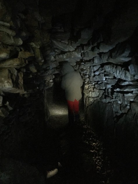
Visiting the mines is quite an experience. We visited three different sections and accessing the tunnels ranged in difficulty from remembering to duck to crawling through a tunnel reminiscent of The Great Escape. Once inside however the tunnels are roomy and easy to negotiate for the most part with the occasional hands and knees crawl or scramble over discarded stone (deads) or fallen roof slabs.

treaclemine_ec_blog-1

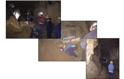
The mines are nothing less than a particularly evocative museum. Mining equipment remains where it was left and footprints from hobnail boots are clearly visible alongside horseshoe prints in the mud (future Anthropocene ichnofossils perhaps). Writing on the walls shows what appear to be customer orders and also the occasional prayer. Unfortunately many of the old rail tracks have been stolen for scrap metal, at least one entrance has been partly filled in by a local caving club to limit access in an attempt to prevent further vandalism, but some do remain and the deep imprint of rails and sleepers is clearly visible. The older parts of the mine pre date the rails and were the domain of horse drawn mine carts. Deep ruts are evidence of the passage of the heavily laden carts and the small stable with its three hitching points is a sobering reminder of how miserable life must have been for the horses. My children also now have a far better appreciation of my occasional threat to send them down the mines.

treaclemine_ec_blog-2

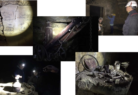
Evidence of mining activity is also present in the rock with tool marks visible on walls and ceilings and soot marks extending up above the candle niches. In numerous places there are rope marks on the walls and parts of the wall cut away to allow the passage of mine carts around the corners. There are also a number of apparently finished blocks of stone left abandoned at the sides of the tunnels for unknown reasons.

Mining artefacts are not the only attraction in this subterranean world. Old wooden props host mushrooms which glow eerily in the light of a UV torch. Cave formations (speleothem) are in evidence in the form of cave pearls and gours. In a number of places these formations are marked by a ring of stones to prevent them from being trampled. Bats also live in these tunnels although we didn’t see any on this occasion.

2

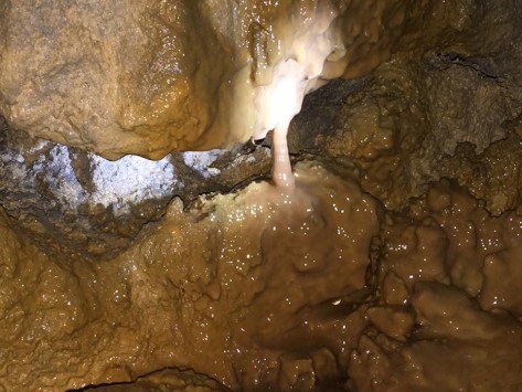
The Earthcache itself is known as The Treacle Mine. This is a nod to an old joke which has been played on the gullible since at least the nineteenth century. It is split into two locations showing two different formations of “Treacle” (calcite and other minerals precipitated from the cave water). At the first location the mineral flows down a vertical wall over decades of graffiti. At the second there are stalactites forming as the water drips down from the roof forming flow deposits on the floor below and the occasional pillar as stalactite meets stalagmite.

1

Having thoroughly explored the tunnels, finding a total of five geocaches we exited through an impressive cavern known as Clapham Junction for perhaps obvious reasons. The cavern itself was formed by the pillar and room mining technique in which blocks of stone are removed but wide pillars are left behind to hold the roof up. The overall effect is of a mediaeval vault on a staggering scale.

The mines are a fascinating place to visit but can be dangerous due to the two main risks of roof fall and getting lost. Go with a guide if you possibly can, maps are also available. Take at least two torches preferably at least one head torch to leave your hands free and wear a hard hat. You will bang your head. Full access conditions and equipment recommendations are available at GC4JEK6 – Below Above – A Tour in Brown’s.


Stoney Littleton Earthcache

Article by Emma Evans, Senior Geophysicist, ION

Stoney Littleton is approximately 6 miles south of Bath and is the site of a Neolithic long barrow. The barrow is situated on top of a hill commanding fabulous views of the nearby village of Wellow and the surrounding Somerset countryside. The barrow is also the subject of an Earthcache –  GC6A6XK – Stoney Littleton.

emma1

I visited with my sons, aged 6 and 9 after a recommendation from a fellow geocacher and it was a fascinating experience. The barrow was probably constructed in about 3500BC and appears to have remained largely intact until it was broken into and plundered for building stone by a local farmer in the 18th century. Human remains were found but have now been lost. The barrow was restored by Thomas Jolliffe in 1858 and after further restoration work is now in the care of English Heritage. Access is by footpath across the fields and it sits on its hillside as it has done for thousands of years   as part of the landscape. There are no information boards or visitor centres here.

Access to the barrow is by way of a square entrance flanked by stone slabs. Inside there is a central passageway approximately 30m long with 3 burial chambers either side. The 6 year old could walk down the middle without ducking, everyone else needed to watch their head. Luckily we had brought torches as the only source of light was the main entrance and the light dwindled as we explored further into the passageway.

emma2

The wall and roof construction seemed remarkably solid given the lack of mortar. There are metal supports visible in a couple of places but it’s impossible to tell if this is down to inadequacies in building or the later scavenging for stone. The local rock here is limestone and the children were delighted to spot a number of fossils in several of the larger blocks.

emma3

This is a great location for an Earthcache. In my experience it’s very unusual to be able to just wander into an ancient monument like this and even though the main scientific interest here is archaeology the rich fossil content of the rock is a good geological talking point. All in all a fascinating place to visit.

Geotourism: The world’s best geological bus trip 

Article by Stephen Pickering

Catch the no.50 bus from Bournemouth rail station for one of the best geological sightseeing tours.  Even better some of the buses, which run hourly, are open topped in summer.  From the train station, the bus first winds through the opulent suburbs of Bournemouth, Poole and Cranford Cliffs before arriving at the glorious large natural Poole Harbour.  From here the bus takes you through magnificent scenery to Sandbanks and across the ferry to Shell Bay, Studland and thence to Swanage.  At Swanage walk along the seafront and then walk (circa 2 km) or catch another bus (no.5) to Durlston Head.  The country park includes Durlston National Nature Reserve and a restored Victorian Castle, with visitor centre and excellent cafe.

Durlston Castle rests on Purbeck Limestones (a local building stone quarried at Anvil Point) but look northwards (as in the photograph) and you can see the Purbeck Limestones at Peveril Point, beyond that Shep’s Bay is where the Wealden and Greensands have been eroded.  The more distant headland is the steeply dipping Chalk Group with Old Harry Rocks at its termination.  Just offshore Elf Enterprise Caledonian carried out exploratory drilling in block 98/12-1.  Beyond Old Harry lies Bournemouth Bay and the offshore extension of Wytch Farm.

Looking westward along the cliff top from Durlston you can see St Aldhelm’s Head (Portlandian), capped by an unusual and enigmatic square boxed chapel with a stone roof.  The chapel was built according to legend by a local man in 1140, after he tragically watched his daughter and her new husband drown as they rowed to their home along the coast.  Also highly recommended is a walk along the cliff top from Durlston to St Aldhelm’s.

The no.50 bus journey takes about an hour.  Of course one of the benefits of retirement is the bus pass (my season ticket to heaven), but in case you do not yet qualify the fare is just £8.50p Return including the ferry, and worth every penny.

Geotourism: Getting lost in Geologic Time

Article by Stephen Pickering

blog steveOne of the great industrial innovations of the late 18th century was the canal, used to transport goods to market it was one of the catalysts of the industrial revolution, and a marvel of innovation and engineering.  I confess to having spent many enjoyable days, holidaying with family and friends on canals in narrow boats, or as they are often called “pleasure boats”.  The latter indicating a transformation from transporting of goods for commerce to that of people for pleasure.  At the end of the day mooring by a canal-side inn for a beer is to me one of life’s greatest pleasures.

In my travels by boat one particular location on the Grand Union Canal, 5 miles east of Leamington Spa has caught my eye.  As the canal descends into the valley of the River Leam by the Stockton of flight of ten locks (often known as ‘the Itchington Ten’), there is a waterside public house called the Blue Lias  http://www.bluelias.com/.   The inn was originally an 18th century farmhouse, apparently it is haunted by the ghost of a red-haired farm labourer who was killed by the enraged farmer who returned from market one day to find his wife in bed with the farmhand. It first became an inn when the early canal travellers stopped for evening refreshment and overnight stabling for their horses.

The pub is named after the Blue Lias which is a locally outcropping limestone shale sequence of late Trias 195 million years ago (Rhaetian stage) through to early Jurassic Lower Sinemurian 200 mya.  It includes the entire Hettangian Stage containing abundant ammonites (Liparoceras) and some early marine reptiles (ichthyosaurs).  The Blue Lias is a transgressive sequence from the lowest member the Wilmcote Limestone representing deposition in a stagnant lagoonal to marginal marine environment.  The anoxic depositional environment caused the precipitation of iron pyrites which contributes to its blue grey colour.  The Blue Lias has been quarried locally for cement, the canal presumably being used to transport the cement to market, elsewhere in the UK the Blue Lias  is used as a building stonehttps://en.wikipedia.org/wiki/Blue_Lias.

So what intrigued me about the Blue Lias, I hear you ask?  Well it is the pub sign shown above, featuring a brontosaur or possible a diplodocus a form of sauropod which was extant from 150 to 155 mya! But what is a mere 50 million years between friends.  Regardless of the pub sign the Blue Lias, the canal and of course the pub are still worth a visit.

Geotourism: The Sedgwick Museum of Geology

Article by Stephen Pickering

As a Geology undergraduate in the early 1970’s I used to visit the architecturally magnificent Victorian Natural History Museum in London, it’s vast cabinets organised with comprehensive fossil and mineral collections in phyllogenic and taxonomic order. Organisms and rocks of every description which both amazed and inspired me by their enormous range and content. Today the Natural History Museum is to me but a sorry shadow of its former self, the beautiful fossil collections swept away, and replaced by animatronic gimmicks and inter-active experiences, even Dippy the Diplodocus has been consigned to the archives – et tu Dippy

Adam Sedgwick, Woodwardian Professor of Geology at Trinity College, Cambridge from 1818 to 1873 (https://en.wikipedia.org/wiki/Adam_Sedgwick), and who first recognised the rocks to define both the Cambrian and Devonian Periods, wrote to his students in 1835 “I cannot promise to teach you all geology, I can only fire your imagination”. His legacy to his successors was a collection of over half a million specimens, including ichthyosaurs specimens purchased from Mary Anning.

In 1904 Thomas Hughes persuaded Cambridge University to open the present Sedgwick Museum of Earth Sciences consisting of more than 2 million specimens including the collection made by Charles Darwin on his voyage on the Beagle, and “Bertie” Brighton the first curator catalogued 375, 000 specimens of the Sedgwick collection. This museum is a time capsule of the history of Geological Science which together with its patrons Sedgwick, Hughes and Brighton, is truly inspirational and certainly fires my imagination.

If you have cause to visit Cambridge University on either business or pleasure the Sedgwick Museum of Earth Science is well worth visiting.

http://www.sedgwickmuseum.org/

Good, good, good, good vibrations

Article by Stephen Pickering

There have not been many good vibrations in the seismic industry recently, with many geophysicists laid off, and equipment lying idle. Just what can we do with all that equipment, including many hundreds of thousands of geophones and accelerometers, after all as Plato said, Necessity is the Mother of Invention?

The Hive is an art installation currently situated in Royal Botanical Gardens, Kew, London, designed by Wolfgang Buttress and others originally for Milan Expo 2015. The installation is 17m high and is a visual and sensual delight representing the life of a bee colony, but what impressed me most were the thousand LED lights inside the Hive which continually flicker and then fade. Why and how I ask?

Well, based upon the research of Dr Martin Bencsik at Nottingham Trent University honey bees communicate by vibrating different pulses in unison. The Hive is connected to real honey bee hives elsewhere in Kew Gardens where accelerometers within the hives detect the sound of honey bee vibrations and convert it into an electrical field which lights up the art installation, the lights oscillating according to the signals from the bees.

Can I image a future world after the hydrocarbon age full of flowers, bees and renewable energy from good vibrations I ask!

As Brian Wilson said in the song;

Good good good good vibrations (Oom bop, bop);

They’re giving me excitations (Oom bop, bop, excitations)

GEOToursim: The Ruta Geologica Transpirenaica

Article by Stephen Pickering

I imagine most of us have already planned a vacation this year, but for those still pondering where to go the Trans-Pyrenean Geological Trail is a great reason to Remain in Europe for your holiday.

The Pyrenees orogenic mountain chain dividing France and Spain, were formed by  the collision of the micro-continent Iberia and the southwestern promontory of the European continental plate.  The two continents were approaching each other since the onset of the Upper Cretaceous about 100 million years ago and were consequently colliding during the Paleogene 55 to 25 million years ago. After its uplift, the chain experienced intense erosion and isostatic readjustments. https://en.wikipedia.org/wiki/Geology_of_the_Pyrenees

The Ruta Geologica Transpirenaica tranverses a 200 km cross-section through the chain which has an asymmetric flower-like structure with steeper dips on the French side.  Starting from Pau in southern France you travel across the Pyrenees to the small village of Murillo de Gállego, in the Aragon region of Northern Spain.  There is no need for extensive walking as at each locality there are explanatory descriptions of the geology on view, the whole trail can be covered by car in a day.  Unfortunately, the information boards are not in English so some preparation is required for those like myself lacking in linguistic skills.  I recommend downloading the field guide from the website http://www.routetranspyreneenne.com/ and selective translation with Google Translate.   Close to the border lies the Parc National des Pyrénées, fantastic scenery and a good place for lunch.

If you feel daunted by the distances and have a need to develop your geological skills then you might consider the NExT course Introduction to Geology.  The course in Pau includes a daytrip along the Ruta Geologica Transpirenaica.  http://www.nexttraining.net/Sessions/Details/30896/Introduction-to-Geology-Including-Pyrenees-Field-Trip.aspx

Once you have completed Ruta Geologica Transpirenaica you may wish to Leave Europe via Bilbao or Santander.

Geotourism, in the land of the dinosaurs

fig1

Dinosaur Provincial Park & The Royal Tyrrell Museum of Palaeontology

Article by Stephen Pickering

I expect many of you may have seen the 1960 movie Lost World starring Michael Rennie, based on the book written by Sir Arthur Conan Doyle in 1912, it depicts a land in which dinosaurs roam freely and you might think it is slightly melodramatic and not particularly authentic. Well if you want to see the real Jurassic world, and Cretaceous for that matter, I suggest a visit to see the Dinosaur Provincial Park (a UNESCO World Heritage site) and the Royal Tyrrell Museum of Palaeontology at Drumheller, in the badlands of Alberta, Canada.
Drumheller lies about 80 miles northeast of Canada’s oil capital Calgary and is certainly worth visiting whenever you get to go to Canada. The badlands which are cut by the Red Deer River and its tributaries includes numerous canyons, mesas and hoodoos. The clastic sediments in the Dinosaur Park are late Cretaceous in age and include the Oldman, Dinosaur Park and Bearpaw Formations in which are abundant fossil remains of fish, amphibians and spectacular dinosaurs. The latter include hadrosaurs, ankylosaurs, stegosaurs, and tyrannosaurs including Albertosaurus sarcophagus which was first discovered by geologist Joseph Tyrrell in 1884. To date more than forty specimens of Albertosaurus sp. have been excavated, the species being much smaller than Tyrannosaurus rex it weighed about two tons but was just as ferocious.
Located in Drumheller is the Royal Tyrrell Museum of Palaeontology, which exhibits dinosaurs and other fossils from not just the Dinosaur Provincial Park but from throughout the world, and including exhibits from the entire geologic column. The presentations focused on dinosaurs are superb with dioramas and reconstructed fossil skeletons of dinosaurs arranged in chronological order (or should I say stratigraphic sequence). The exhibits are not just dinosaurs, other exhibits include; “Lords of the Land” a diorama of the most dangerous theropods, and exhibits covering topics such as the Burgess Shale, and marine reptiles. A window into the “Preparation Lab” allows visitors to watch technicians as they prepare fossils for research and exhibition. I particularly liked the fossil dinosaur eggs though I confess they were a bit too large for my egg cup.
I personally believe the Royal Tyrrell is one of the great museums of geology and certainly worth a visit by any geoscientist.

fig2Albertosaurus sarcophagus with attitude

fig3
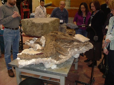
Preparation laboratory

fig4
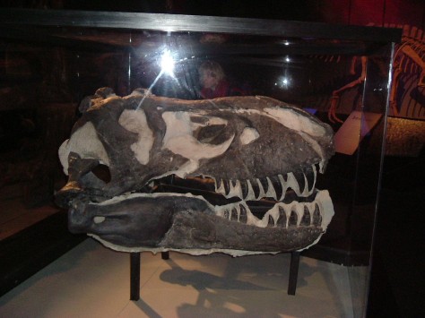
Now where did Steven Spielberg get the idea for Jurassic Park!
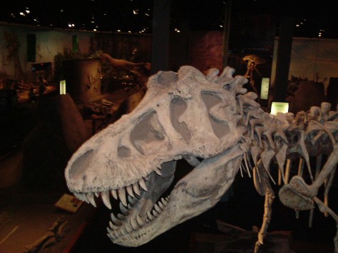
fig6Walkies!!!

Probably the best field trip* in the world ever!

(*and it wasn’t even a field trip)

An account of a road trip through south-western USA, Summer 2014
Part 3 of 3: Yosemite to Las Vegas

By Graham Pritchard, Serica Energy

1
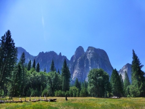
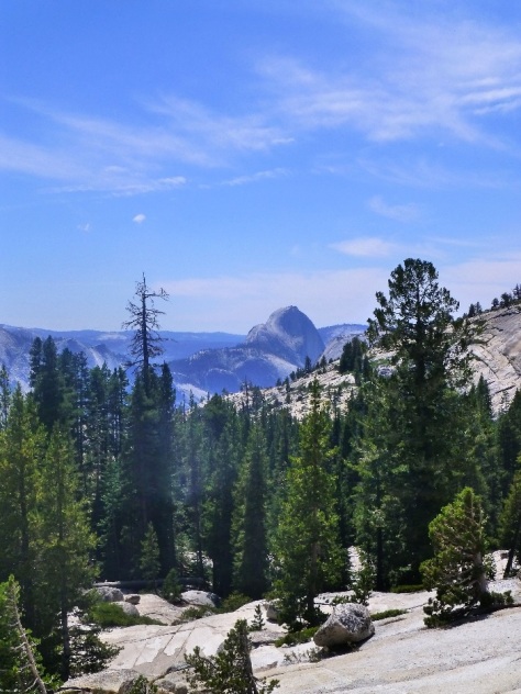
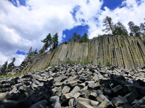
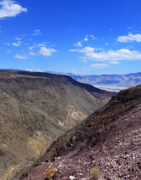
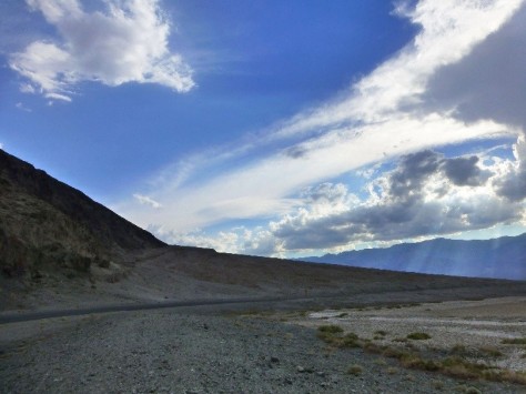
Two years ago decided, as a family, we decided to undertake a road trip across south-western America, taking in Las Vegas, Palm Springs, Los Angeles, and San Francisco. Being put in charge of coming up with the itinerary, it was perhaps not surprising that I came up with some geological stops en-route. Our tour traversed parts of the relatively stable Colorado Plateau, the more heavily-deformed “Basin and Range” Province, as well as the tectonic crush zone that is the Californian Pacific Coast. The first two legs of this trip, from Las Vegas to Los Angeles via the Grand Canyon, and then onwards to San Francisco and Yosemite, I described in the first two instalments. This third and last piece covers the section from Yosemite back to Las Vegas via Death Valley.

Crossing the Tioga Pass, which marks the watershed across the Sierra Nevada Mountains, we drove down into a series of rifted basins characterised by extensive volcanic and hydrothermal activity that remains active to the present day. From here, we headed to June Lake, a stunningly beautiful mountain resort that was well off the beaten track in comparison to the crowds at Yosemite we had just left behind.

Close by is Mono Lake, a large highly alkaline body of water with no natural outlet. Mono Lake has numerous travertine pinnacles precipitated by hydrothermally-charged spring waters. It is best visited at sunrise or sunset, where the low light set against the back-drop of pinnacles creates a surreal atmosphere. Mono Lake will be very familiar to fans of Pink Floyd’s album “Wish You Were Here”, as it features on the album cover a man hand-standing in the water mirroring the backdrop of the travertine spires. Mono Lake may also be familiar to fans of South Atlantic “pre-salt” carbonate reservoirs, as a possible very small-scale analogue for hydrothermally-enhanced microbialite carbonate deposition. Adjacent to the lake, a series of small, perfectly-formed rhyolitic tephra craters plugged by obsidian perfectly completes the association of lacustrine, volcanic and hydrothermal processes. Warning – if you are (like I was) wearing on your feet nothing but sandals, you will cut your feet to shreds on the obsidian scree.

2

3

5

4


South of Mono Lake, volcanic geology becomes increasingly dominant, although paradoxically this isn’t immediately obvious even to the geologically trained eye. The area centres on the so-called “Long Valley Caldera”. OK, this is only about a quarter of the size of Yellowstone, but that’s a pretty huge caldera nevertheless, and it remains very much alive. It is bristling with seismic monitoring stations, as next to an earthquake, a mega-eruption is the next biggest geological catastrophe-in-the-making that makes Californians get twitchy. The potential size of the next eruption is illustrated by thick layers of tuff (reaching over 500ft thickness and covering many hundreds of square miles) that were produced by a single catastrophic event less than a million years ago that blew away much of the pre-existing volcano. Today, however, the volcanic activity manifests itself in bubbling hot springs, fumaroles and ongoing seismic micro-seismicity.

The centrepiece of the Long Valley Caldera is Mammoth Mountain, which is actually a large dormant volcano complete with fumaroles, but is better-known for the ski resort built upon its seasonally-snowy flanks. Also on the flanks of Mammoth Mountain is the “Devil’s Postpile”, a spectacular cliff face composed of hexagonally-jointed basalt that flowed into a valley between Mammoth Mountain and the Sierra Nevada, before cooling in-situ. The valley was subsequently scoured out by glaciers during the last ice age leaving remnants of the columnar basalt preserved along the valley sides. Climbing to the top of the outcrop, one can stand on top of the ice-striated hexagonal columns.

6

Onwards from here, we drove southwards through Owens Valley, an immense rift located just east of the massive footwall of the Sierra Nevada, topped by Mount Whitney which at 14,505 feet forms the highest mountain in the contiguous USA. The floor of Owens Valley is studded by numerous small lava flows and cones, some of which appear to be very recent in origin. Then, at Lone Pine, (the scene of many early “western” films), we headed eastwards, back into the “basin and range” province, for what was to be the piece de resistance – the Death Valley National Park.

7

Death Valley National Park is huge (in fact the largest national park in the USA) and comprises numerous “basin and range” rifts and mountains, of which Death Valley itself is just one small segment.  On driving down into the first rift basin, we made a random stop at a viewpoint beside a gorge, which cut through a beautiful sequence of steeply-dipping strata topped by a classic unconformity. It was getting pretty close to geological nirvana by this point!

Onwards to Stovepipe Wells, within Death Valley itself, for a short stop to view the wind-blown sand dunes. And another word of warning – do not, if you are still (as I was) foolishly wearing just sandals on your feet, run out enthusiastically onto the sand, as you will get your feet blistered! The temperature topped 118 degrees Fahrenheit (48 degrees Centigrade) in the shade that day. Yet another word of advice – keep plenty of drinking water in the car and always stay hydrated.

Death Valley was for me the highlight of the trip. Unlike the Grand Canyon, for which (unless you hike down it), the geology must be viewed from afar, Death Valley offers the chance to get down and dirty with the rocks themselves. A lot of Death Valley is also accessible by car without the need for four-wheel drive, and (compared with the Grand Canyon South Rim) is relatively devoid of tourists, certainly in the extreme heat of high summer. One of the hottest, driest and deepest sub-aerial basins on the planet, It’s difficult to know where to start with the geology. However, the, bouldery alluvial fans around the appropriately-named Furnace Creek, and the salty evaporite pans of the Devil’s Golf Course and Badwater Basin are good places to start. Given the recent rainy weather, parts of the salt flats were actually covered in standing water, and that afternoon, lively thunderstorms rumbled across the nearby Panamint Mountains.

8

Well worth a visit was the so-called “Artist’s Drive”, where hydrothermal mineralisation had coloured the rocks bizarre shades of blues, greens and yellows. It was also stunning to see apparently recently-formed alluvial fans that had been cross-cut by normal faults. Food for thought for any petroleum geologists working on syn-rift reservoirs within hanging-wall settings…

9

If you are staying in Death Valley, a pre-dawn start to see the sun rise across Death Valley from Zabriske Point and Dante’s View is an appropriate finale to such a fantastic tour. Dante’s view is almost 5000 feet above the level of the valley, and at that time of day, the altitude provides a welcome respite from the stifling heat of the valley below. The long shadows at sunrise brings out all the topography of the rift into sharp perspective. Highly recommended!

10

It was sort of metaphorically (if not geographically) down-hill from there onwards. A long drive back to the casinos and less than alluring glitz of Las Vegas. For the true hard-core geologist, you might still want to make a short diversion just outside Vegas, via Red Rocks Canyon. Here, bright red aeolian sand dunes of Jurassic age are exposed via a series of thrust faults. However – beware! By this point, your family, if they have not already mutinied, will almost certainly do so now. And you may find divorce papers waiting for you when you get home. But with a bit of luck, and some careful planning, everyone will have had a great time!

Probably the best field trip* in the world ever!

(*and it wasn’t even a field trip)

An account of a road trip through south-western USA, Summer 2014
Part 2 of 3: Las Vegas to Los Angeles

By Graham Pritchard, Serica Energy

map1
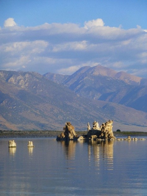
It was two years ago that we agreed to have an extra-special family summer holiday. Deciding on a road trip across part of America, my family came up with a list of places to visit: Las Vegas, Palm Springs, Los Angeles, San Francisco … All I had to do was come up with the itinerary.  Some surfing around the region via Google Earth showed that it would be possible to link the above cities with some very interesting geological localities indeed, traversing parts of the relatively stable Colorado Plateau, the more heavily-deformed “Basin and Range” Province, as well as the tectonic crush zone that is the Californian Pacific Coast.

The first leg of the ensuing road trip, from Las Vegas to the Grand Canyon and then Palm Springs and Los Angeles, I described in the first instalment. This second piece covers the section from Los Angeles, up the Pacific Coast to San Francisco, and then inland to Yosemite.

prit2Arriving in Los Angeles, we had a couple of days in which the geology took a back-seat. The famous “La Brea” tar-pits are surprisingly located only a mile from Beverly Hills and Hollywood, although sadly I never got around to visiting them. But I could rest assured with the knowledge that numerous prolific oil fields are located directly beneath the city. In the case of La Brea, it is underlain by the Salt Lake Field, which produced over 50 million barrels of oil between 1902 and abandonment in 2001 to make way for a new shopping mall. The Los Angeles petroleum system developed in deep pull-apart basins controlled by the San Andreas Fault, with oil in Miocene sandstone reservoirs trapped within complex thrust-cored anticlines. There’s surprisingly little to tell these days of the city’s oily heritage, although one obvious exception is a series of oil production platforms clearly visible a short prit3distance offshore of the coast between Santa Monica and Santa Barbara, northwest of Los Angeles.

Meanwhile, a trip along Mulholland Drive (home of many film stars, and location of the eponymous David Lynch movie) afforded spectacular views of the “Hollywood” sign as well as the sprawling urban Los Angeles city-scape. However, a glance in the other direction revealed the fault-scarp immediately north of the urban area of Burbank, clearly a very young and tectonically-active feature. In Los Angeles, the geology is never far away…

After several days in LA, our journey continued north-westwards along California’s famous Route 1, which hugs the Pacific coastline (in some places, quite literally) all the way to San Francisco. This is a surprisingly long journey that took us a full two days, with the road in places a seemingly never-ending succession of scary cliff-top hairpin bends. The scenery is truly world-class, especially along the section known as the “Big Sur” between the sleepy town of Cambria (a hang-out of ageing hippies and alternative life-stylers) and the uber-upmarket resort of Carmel. As for the geology, suffice to say that the rocks along this mountainous coastline are a chaotic series of contorted sediments, volcanics and melanges uplifted as the now-subducted Farallon tectonic plate squeezed its way under the North American Plate, before the right-lateral San Andreas Fault system took hold. These rocks are exposed all the way up the coastline, but are way too complex to comprehend on a tour like this.

gra1

gra2

North-west of Santa Cruz, where the coastal scenery becomes more subdued and mellow, was one of my more sneaky geological stops. I had read about the Panoche sand-injectite complex, inland of Santa Cruz, but this is located in mountainous off-road territgra3
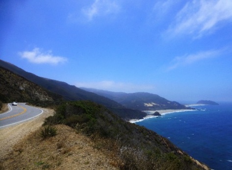
ory and to propose a visit here would have incited my family to mutiny.

However, I knew of similar sand injectites exposed in cliffs in the Santa Cruz area. Locating them would be tricky, but I knew approximately where they were through a combination of academic publications and Google Earth. So at what I thought was roughly the right place, I feigned the need for a late lunchtime stop to “stretch my legs” and sauntered down a path to the rocky cove below. The sand injection dyke which I found down there was stunning, and is shown in the accompanying photograph.

We then spent a couple of days in San Francisco, with obligatory visits to Devil’s Island, the Golden Gate Bridge, Chinatown and the Fishermans Wharf area. Then another long drive, this time eastwards, inland towards the Sierra Nevada Mountains and Yosemite National Park. At first, this seemed like a tedious journey across the flat agricultural plains of California’s Great Central Valley. The valley is pretty much all that remains of a back-arc basin formed as the Farallon Plate subducted under North America. Depending on which route you take over the Central Valley, you might spot oilfield nodding donkeys amongst the orange groves.

Eventually, the road begins a long and winding ascent into the pine-forested foothills of the Sierra Nevada, before reaching Yosemite Valley nestling beneath the mighty Half Dome.

grap4

Yosemite defies description, both in terms of the spectacular scenery of immense granitic cliffs, hanging valleys and waterfalls, but also the sheer volume of granite, an observation that applies not just to Yosemite but the Sierra Nevada Mountains in general. Intruded over a long period of time during the Cretaceous, the Sierra Nevada granites are yet another manifestation of the subducting Farallon Plate, with huge volumes of melt rising upwards into and eventually crystallizing within the overlying American Plate. As a British geologist accustomed to believing that the UK’s Cornubian Batholith, with its outcrops of granite poking through at Dartmoor and Bodmin Moor, is a large-scale feature; well the sheer scale of the Sierra Nevada intrusions in comparison is simply mindboggling.

Onwards from Yosemite, the road winds on and on and up and up eastwards towards the Tioga pass, which at 9943 feet elevation marks the watershed across the Sierra Nevada Mountains. Beware – for anyone attempting to travel this route outside of summer, the road is typically shut for six months of the year due to snow drifts, and a detour would involve several hundred miles of extra driving. As one gains elevation towards the pass, the pine forests thin out and the landscape becomes increasingly dominated by huge bare slabs of glacially-scoured sparkly light grey granite.

By comparison with the long, steady drive up the western flanks of the Sierra Nevada, the eastern margin is fault-controlled and the road drops precipitously beyond the Tioga Pass into a series of deep rifted basins.  From here, we headed to June Lake, a beautiful and quiet mountain resort. I’ll enthuse about the geology of this area, and that of Death Valley, in the next and final instalment.

gra5