
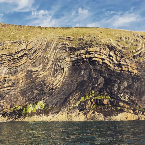
Newport on the North Pembrokeshire coast. Heavily folded Ordovician sandstone and shales
From Douglas Winstone
Share your ‘Gneiss’ Rocks
Email blog@pesgb.org.uk with your photos

Newport on the North Pembrokeshire coast. Heavily folded Ordovician sandstone and shales
From Douglas Winstone
Share your ‘Gneiss’ Rocks
Email blog@pesgb.org.uk with your photos
Hutton Sequence
From Dario Chisari
Share your ‘Gneiss’ Rocks
Email blog@pesgb.org.uk with your photos
Desiccated mud flakes in an Oued, Sahara Desert, Morocco
From Andrew Cook, GTC Interpretation Application Support, Chevron Energy Technology Company

Share your ‘Gneiss’ Rocks
Email blog@pesgb.org.uk with your photos
Wadi Turyut, Hadramut, Yemen.
Pillars eroded into Um er Radhuma limestone on Wadi Taryut floor. Wadi walls are vertical, humans for scale.
From Peter Bryant, Redhill Resources Limited

Share your ‘Gneiss’ Rocks
Email blog@pesgb.org.uk with your photos
Normal fault in the Mârmorilik Formation of the Palaeoproterozoic Karrat Group, above the Affarlikassaa fjord, Central West Greenland
From Gareth Digges La Touche

Share your ‘Gneiss’ Rocks
Email blog@pesgb.org.uk with your photos
Aeroplane photo of normal fault in wall of Wadi Turyut, Hadramut, Yemen.
Foot wall to right (north) has Jeza Formation outcropping at surface. Hanging wall to left is capped with Jeza Formation and underlain with the massive Umm er Radhuma limestone.
From Pete Bryant, Redhill Resources Limited

Share your ‘Gneiss’ Rocks
Email blog@pesgb.org.uk with your photos
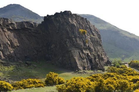
Hutton’s Unconformity – Isle of Arran
Although not as obvious as unconformities that he identified later (Siccar Point, for example), the exposed unconformity on the Isle of Arran is arguably where the science of modern Geology began. James Hutton’s field work on Arran (and other places) led to his Theory of the Earth which he presented as a paper at a meeting of the Royal Society of Edinburgh in 1785 and which he published as a book in 1788.
Hutton found this, his first unconformity, to the north of Newton Point near Lochranza on the Isle of Arran. It occurs where near-vertically dipping Precambrian Dalradian schists are overlain by more recent Lower Carboniferous sandstones with an obvious difference in dip between the two rock layers. The older pre-Cambrian rocks in the photograph are in the foreground, dipping downward to the left; the overlying Carboniferous sandstones dip towards the sea in the background.
From Ian Relf, Seismic Experts Company Limited

Share your ‘Gneiss’ Rocks
Email blog@pesgb.org.uk with your photos
Cross-bedding and ripple marks (sedimentary structures) in Lower Carboniferous rocks (Dinantian) outcropping at Cargie’s Plantation (Berwick-upon-Tweed).
From Oscar Miron, Senior Geophysicist, LR Senergy

Share your ‘Gneiss’ Rocks
Email blog@pesgb.org.uk with your photos
Sunnyside beach, between the localities of Cullen & Portsoy (NE Scotland, Moray Firth)
Psammites & semipelites of the ‘Findlater Flag Formation’ aged c.542-1000my. Type locality named after the nearby medieval Findlater Castle
From Carmen Garcia-Carballido, Subsurface Advisor, ASTURALBA Limited

Share your ‘Gneiss’ Rocks
Email blog@pesgb.org.uk with your photos

A view westwards down Hope Valley in Derbyshire from Stannage Edge showing elements of the submerged Carboniferous petroleum system explored in the East Midlands. Proximal Namurian gritstones overlay pro-delta turbidites which in turn overlay the organic rich Edale/Bowland shales which are currently being explored for shale gas and provide oil and gas charge to most of the UK onshore petroleum system (e.g. East Midlands).

The same Carboniferous Gritstones at Stannage Edge looking northward with large truncation surfaces in conglomeratic prograding foresets. Partially hewn millstones can be seen in the foreground.
From Tim Wright, Merlin Energy Resources
Share your ‘Gneiss’ Rocks
Email blog@pesgb.org.uk with your photos


